Showing posts with label xml. Show all posts

Thursday, February 21, 2008

PRAP and Geography Markup Language (GML)

I have begun moving PRAP's GIS data from ESRI shapefiles into Geography Markup Language (GML) and have included the resulting files in the pre-release version of the PRAP Digital Archive.

The initial conversion was easy. I used the macports.org site to install the GDAL libraries, which include tools for working with vector data. Converting the shapefile that represents the tracts PRAP walked required only executing the command 'ogr2ogr -f "GML" tracts.gml tracts.shp'. This produced an xml file in gml format that required just a little cleaning to be on its way to something that I'll be comfortable archiving. Here's an example of how the outlines of a tract are currently represented in that file:
<gml:featureMember gml:id="prap:collectionunit:K94-001">
<gml:geometryProperty>
<gml:Polygon>
<gml:outerBoundaryIs>
<gml:LinearRing>
<gml:coordinates>15200.344657999999981,28729.004949499998474 15213.297062499999811,28831.356068500001129 15221.920192999999927,28827.91327050000109 15228.021194499999183,28823.439226499998767 15222.873737500000061,28762.960040000001754 15268.410846500000844,28761.380233500000031 15266.11084800000026,28728.121744000000035 15200.344657999999981,28729.004949499998474</gml:coordinates>
</gml:LinearRing>
</gml:outerBoundaryIs>
</gml:Polygon>
</gml:geometryProperty>
</gml:featureMember>

Sure, GML is verbose but that's not a problem since I'm delivering the archive as a compressed tar ball. An actual problem is that the PRAP data is not currently georeferenced so that the co-ords you see above represent an arbitrary grid the project established for its study area. Converting this grid to UTM is doable and is "on my list".

After a few more conversions, the files "tracts.gml", "coast.gml", and "surveyed.gml" can be found in the "spatial/gml" directory of the archive. I have displayed all of these in the open source mapping application QGis so that I know they're passable GML, if not fully compliant with the latest version of the standard.

I have also added an examples directory. The only files in there now are "mapars.xsl" and "ars.gml". "mapars.xsl" is a style sheet that will query the pottery records in the file 'compiled/prap_gml.xml' to find the African Red-Slip, extract the tracts in which those sherds were found, and write that list to a gml file that can likewise be displayed in QGis or any other GML-aware mapping program. Here's the stylesheet:
<?xml version="1.0" encoding="utf-8"?>
<!--
Running 'xsltproc mapars.xsl ../compiled/prap_gml.xml > ars.gml'
will produce a gml file showing tracts where African Red-Slip (ars) was
recorded.
-->
<xsl:stylesheet version="1.0" xmlns:xsl="http://www.w3.org/1999/XSL/Transform"
xmlns:x="http://www.w3.org/2002/06/xhtml2/"
xmlns:gml="http://www.opengis.net/gml"
xmlns:exsl="http://exslt.org/common"
extension-element-prefixes="exsl">
<xsl:output method="xml" encoding="utf-8" indent="yes"/>

<xsl:key name="classes" match="//*[@class]" use="@class"/>
<xsl:key name="ware" match="//x:div[@class='pottery']" use="x:span[@property='ware']"/>
<xsl:key name="gml:ids" match="//*[@gml:id]" use="@gml:id"/>

<xsl:template match="/">
<gml:FeatureCollection xmlns:gml="http://www.opengis.net/gml">
<gml:boundedBy>
<gml:Box>
<gml:coord>
<gml:X>14625.166504</gml:X>
<gml:Y>13709.92893965028</gml:Y>
</gml:coord>
<gml:coord>
<gml:X>35518.298225</gml:X>
<gml:Y>30227.18022459958</gml:Y>
</gml:coord>
</gml:Box>
</gml:boundedBy>

<xsl:for-each select="key('ware','African Red-Slip')">
<xsl:variable name="cuid" select="concat('prap:collectionunit:',x:span[@property='cuidentifier'])"/>
<xsl:copy-of select="key('gml:ids',$cuid)"/>
</xsl:for-each>
</gml:FeatureCollection>
</xsl:template>

</xsl:stylesheet>

"ars.gml" is the mappable gml file; see the comment at the top of the stylesheet for the command that will generate it once you've unpacked the tar ball.

To be clear, I think this is incredibly cool. PRAP is now moving towards a consistent xml-based representation for all its data other than digitized photographs. I've already written about using svg to represent ceramic profiles. I will apply the same technique to PRAP's drawings. This consistency of representation will allow PRAP to use the same set of open-source tools to manipulate, analyze, report on and publish its results. And not only will we be able to publish the base data and the results, we will be equally clear about the processes that were applied to the data in order to reach our interpretations.

Data, algorithms and results will all be there for everyone to see. Or at least, that's the idea. There's a long way to go before it happens.

Thursday, February 7, 2008

PRAP Images: From Join Table to Containment

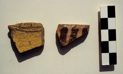
In my ongoing effort to create an archival version of PRAP's field data, I'm looking at how we dealt with image metadata and what we want to do now. A basic issue with the photographic record of an archaeological field project is that each photo can be of multiple subjects and each potential subject - a site, a tract, a piece of pottery - can appear in multiple photos. Photograph 203.29 is an example.

These relationships aren't very hard to handle in an adequate fashion with a modern database using a straigtforward many-to-many structure. At PRAP we had a table listing photographs and a separate table listing what identifiable entities appeared in each photograph. The latter can be called a join table. A schematic representation of the content of image 203.29 would be as follows:

Photographs
id: 203.29
filmtype: color slide
caption: byz sherds from area B.

Image<->Subject Join Table
photo_id: 203.29
subject_id: B92-181-02
position: left

photo_id:203.29
subject_id: B92-181-03
position: right

Sherds
id:B92-181-02
<info about sherd>

id:B92-181-03
<info about sherd>

I'm skipping over a whole lot of detail but I hope it's clear that this establishes that sherd B92-181-02 is the object at the left of photo 203.29. You can see this information put into action with further links on the PRAP website, which is serving the filemaker versions of our databases.

At this point I should say that it was Debi Harlan, now of the excellent ArchAtlas project, and I who implemented this system in the field.

One way to represent this many-to-many concept in xml is just to wrap markup around the records of the join table and leave it at that. For example:


Image<->Subject Join
<div class="imagelink">
<span property="image" src="prap:image:203.29" />
<span property="subject" src="prap:pottery:B92-181-02" />
<span property="position">Left</span>
</div>
<div class="imagelink">
<span property="image" src="prap:image:203.29" />
<span property="subject" src="prap:pottery:B92-186-03" />
<span property="position">Right</span>
</div>

Image Info
<div class="image" id="prap:image:203.29">
<span property="filmtype">CS</span>
<span property="label">Late Byzantine decorated base contiguous to Site B02, Kavalaria; Byzantine decorated bowl rim from B team tract</span>
<span property="photologdescription">B-92-181-2 (left), B-92-186-3 (right), respectively LByz decorated base, Byz decorated bowl rim</span>
</div>

You can see that each 'imagelink' div refers to a separately instantiated image and a separately instantiated subject. Unfortunately, there is some fragility and a lot of unnecessary overhead to this structure. The fragility comes from the possibility of change in one the joined tables. Perhaps "203.29" was a typo in the database. If you change the id of a photo, it needs to be changed in the join information as well.

XML allows one to take advantage of containment to incorporate the link information directly into the image database as follows:

<div class="image" id="prap:image:203.29">
<span property="filmtype">CS</span>
<span property="label">Late Byzantine decorated base contiguous to Site B02, Kavalaria; Byzantine decorated bowl rim from B team tract</span>
<span property="photologdescription">B-92-181-2 (left), B-92-186-3 (right), respectively LByz decorated base, Byz decorated bowl rim</span>
<span property="subjects">
<span>
<span property="subject" src="prap:pottery:B92-181-02" />
<span property="position">Left</span>
</span>
<span>
<span property="subject" src="prap:pottery:B92-186-03" />
<span property="position">Right</span>
</span>
</span>
</div>

I'm not yet happy with the details of this markup. Among the many odd things is the extra 'span' surrounding each subject-position pair. I'd like to call that something. The advantage of this representation is that the text from <div> to </div> is a self-contained description of the image with well-structured links to the named entities that appear within it.

One last point... I was not about to cut-and-paste the subject info into each image div. Instead, I wrote a quick-and-dirty xslt stylesheet to process the two xml datasets and produce a single set of image descriptions that point to their subjects. Here it is:

<?xml version="1.0" encoding="utf-8"?>
<xsl:stylesheet version="1.0"
xmlns:xsl="http://www.w3.org/1999/XSL/Transform"
xmlns:x="http://www.w3.org/2002/06/xhtml2/" >

<xsl:key name="classes" match="//*[@class]" use="@class"/>
<xsl:key name="srcs" match="//*[@src]" use="@src"/>

<xsl:template match="/">
<xsl:for-each select="key('classes','image')">
<div class="{@class}" id="{@id}">
<xsl:copy-of select="./*"/>
<span property="subjects">
<xsl:for-each select="key('srcs',@id)/..">
<span>
<xsl:choose>
<xsl:when test="count(x:span[@property='subject']) &gt; 1">
<xsl:apply-templates select="x:span[not(@property='image')]"/>
</xsl:when>
<xsl:otherwise>
<xsl:copy-of select="x:span[not(@property='image')]"/>
</xsl:otherwise>
</xsl:choose>
</span>
</xsl:for-each>
</span>
</div>
</xsl:for-each>
</xsl:template>

<xsl:template match="x:span">
<xsl:if test="not(contains(@src,':collectionunit:'))">
<xsl:copy-of select="."/>
</xsl:if>
</xsl:template>

</xsl:stylesheet>

This stylesheet has now been used to combine the image and image link portions of the PRAP Digital Archive and the tar ball has been updated.

I realize that I'm diving right into xml, xslt, etc. without much explanation. One purpose of this post is simply to share notes on what I've done. The other is to move towards the idea of a "PRAP Digital Archive Cookbook" that illustrates how to work with the PRAP data. This post can't be the beginning of such a publication since it has described a process that changed the underlying files in such a way that the just quoted xslt stylesheet will no longer work. But stay tuned for more fun things to do with this developing dataset...