Showing posts with label troy. Show all posts

Wednesday, April 7, 2010

Screen shot of Troy pottery on iPad

Quick post...

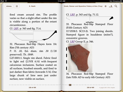
Here's a screen shot of Greek, Roman and Byzantine Pottery at Ilion (Troia) on an iPad. This is in the default reader iBooks.


You can click through to the Flickr page to get the full-size image. This gives a sense of the dimensions of the iPad screen.

OK, lots of work to do to make the page layout better, but I will admit to thinking this is cool.

Some annoyances: This volume is co-edited with Billur Tekkök but only "S. Heath" is showing up at the top. The underlined links don't work. That's also the case in the Stanza ePub reader on my iPhone. Desktop ePub readers do follow links (or at least some of them do). I think they all should, regardless of device.

There will be more to say so stay tuned. The brief "take away" is that eReaders will be one channel for the distribution of archaeological data. I look forward to RadioSchack and the like selling color devices for somewhere between $79.00 and $179.00

p.s. You can get the file here: bit.ly/troyepub .

Wednesday, June 4, 2008

Mapping GRBPIlion

I continue to be interested in using the Atom Syndication Format, Georss, KML and Google's mapping tools to express the geographic component of data related to the ancient Mediterranean. These formats are all simple, well-documented and xml-based so that Greek, Roman and Byzantine Pottery at Ilion (Troia), in which we try to use open standards, is a good test-bed for trying out ideas.

To cut to the chase, the following URLs show what I'm up to:Clicking on the Google Maps link shows a browser-embedded map with a short list of sites on the left. It's early yet, but that list will expand. Regardless, clicking on a site name on the left will bring up a text-bubble pointing to the right place on the map. Within the bubble are one or more links to relevant pages on the GRBPIlion website. Imagine more dots and you get the idea.

The implementation is pretty simple but should give me flexibility going forward. There are three basic components. The file "geography.atom" defines geographic entities. If you look inside you'll see that I derive unique IDs from the Barrington Atlas, so Gaza is "http://atlantides.org/batlas/gaza-70-e2". In doing so, I follow the suggestions of Tom Elliot of ISAW. Looking inside "groups.xml" - which instantiates concepts such as "African Red Slip" for rendering into html - shows that a few such groups make reference to these geographic entities. Search for 'rel="geographic"' to see what I mean. Finally, I munge those two files into "grbpilion.kml", which can be shown directly in Google Earth or via Google Maps using the URLs listed above.

The xslt that does the munging is "kml.xsl". It's pretty ugly right now but it works so will do for the short term.

At a more abstract level, I can theoretically put elements such as '<link rel="geographic" href="http://atlantides.org/batlas/gaza-70-e2" />' anywhere in the publication. Right now I only implement this idea in groups.xml but I look forward to extending this system to individual sherd descriptions and to the bibliography.
Monday, December 17, 2007

Don't Buy This Book

PDQ SubmissionAs I've mentioned before, Billur Tekkök and I are editing the digital publication Greek, Roman and Byzantine Pottery at Ilion (Troia). I'll talk about our work as part of the AIA panel "Web-Based Research Tools for Mediterranean Archaeology".

One point that I will stress is that we intend to deliver this information in whatever formats will be useful to users. Currently, this means the website, a PDF file released under a Creative Commons license, and as a bound volume available for purchase from Lulu.com. It's pretty trivial to generate the PDF - which we produce so that users can take all our content into the field - and then upload it to Lulu, after which third parties can purchase a printed copy.

That last "format" brings me to the title of the post. Don't buy the bound version yet. I'm going to update it at least once before going to Chicago and, looking further out, our goal is to expand the content in time for the summer field season. This is all to say that the whole thing is a draft so there's no point in spending real money when you can get all the text and images for free.

If that's the case, why are we producing a bound version at all? At some point we'll freeze a first edition and submit it for review and encourage libraries to purchase it. There's still a role for a printed volume as an archival format and there are still times when it's convenient to have information available on the printed page; like when it's over 37 Celsius and you don't want to bring your computer outside into the heat and dust.

Information when you want it and how you want it is the model we're pursuing, even if that means using such old-school technologies as the printed book.

And one reason to buy now... if you'd like to see the quality of Lulu volumes. In general, I can say that the paper quality is good, text is sharp, but the image reproduction is only decent, though I think I can tweak the process to make the images more faithful to their original colors and quality.